- GNSS


- Motion of the Earth's tectonic plates
- Regional deformation and local uplift or subsidence.
- Definition of the celestial reference frame
- Variations in the Earth's orientation and length of day
- Maintenance of the terrestrial reference frame
- Measurement of gravitational forces of the Sun and Moon on the Earth and the deep structure of the Earth
- Improvement of atmospheric models
Very Long Baseline Interferometry (VLBI) overview
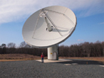 |
VLBI is a geometric technique: it measures the time difference between the arrival at two Earth-based antennas of a radio wavefront emitted by a distant quasar. Using large numbers of time difference measurements from many quasars observed with a global network of antennas, VLBI determines the inertial reference frame defined by the quasars and simultaneously the precise positions of the antennas. Because the time difference measurements are precise to a few picoseconds, VLBI determines the relative positions of the antennas to a few millimeters and the quasar positions to fractions of a milliarcsecond. Since the antennas are fixed to the Earth, their locations track the instantaneous orientation of the Earth in the inertial reference frame. |
 |
The celestial reference frame is defined by VLBI. The International Astronomical Union has adopted over 3400 extragalactic radio sources (mostly quasars) used by VLBI as the defining objects of the celestial reference frame. Extragalactic objects form a true inertial reference frame because they are at such great distances that their motions across the sky are undetectable. Positions of stars in our galaxy are now tied to this reference frame, and this is the same reference frame used for measuring Earth orientation. VLBI is unique in its ability to make rapid, accurate measurements of the orientation of the terrestrial reference frame with respect to the celestial reference frame. |
 |
VLBI observations are sponsored by over 40 organizations located in 19 countries. VLBI determines with unequaled accuracy the terrestrial reference frame (antenna locations on the Earth), the celestial reference frame (quasar positions on the sky), and Earth's orientation in space. This map of VLBI sites is also available in PDF form. |
The International VLBI Service for Geodesy and Astrometry (IVS) is an international collaboration of organizations which operate or support Very Long Baseline Interferometry (VLBI) components. IVS provides a service which supports geodetic and astrometric work on reference systems, Earth science research, and operational activities. The IVS groups geodesy and astrometry together because they use the same observations and the same analysis gives both types of results. IVS is established under the International Association of Geodesy (IAG).
Some of the scientific results derived from VLBI include:


NASA Official: Rivers Lamb
Web Curator: Lori J. Tyahla
FAQ
Earthdata Forum
Contact Us
Last updated: Mar 31, 2020
Web Curator: Lori J. Tyahla
FAQ
Earthdata Forum
Contact Us
Last updated: Mar 31, 2020